Analyzing and Mitigating Multipath Error in the Indian Regional Navigation Satellite System for Improved Performance
Abstract
ISRO developed a navigation-based IRNSS satellite system to reduce India’s dependency on other countries’ navigation systems. It is mainly useful for navigating positions in India. They face some problems like multipath error, ionospheric error, etc. Out of all, a multipath error was the most degradation factor in the performance of IRNSS. These multipath errors occurred due to the bouncing or reflection of signals from satellites on any surface on the earth causing delays in receiving the signals by the receiver. To reduce the multipath error, the code minus carrier (CMC) technique was used with LMS filters. The CMC technique is used to estimate the multipath error and the LMS filter is used to mitigate that estimated error. This mitigation process is performed using MATLAB 2022b.
Code Description & Execution ofAnalyzing and Mitigating Multipath Error in the Indian Regional Navigation Satellite System for Improved Performance
Algorithm Description
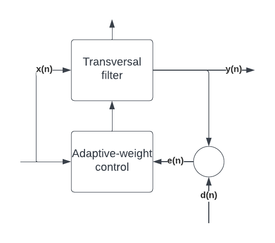
Fig 1: Block diagram of the adaptive transversal filter
ISRO developed the Indian Regional Navigation Satellite System IRNSS. It was developed to make India independent of foreign navigating systems. Up to 1500km of the Indian landmass can be navigated with them. Military applications and defense forces in India mostly benefit from them. The IRNSS has seven satellites. They provide two types of services namely Standard position service and Restricted service. The IRNSS system faces a few problems like multipath error, ionospheric error, etc. Multipath errors, however, degrade IRNSS performance the most. This project focuses on the mitigation of multipath errors from IRNSS.
The multipath error occurs when the signals from the satellite transmitter are bounced or reflected from surfaces of buildings, water, or any other surfaces. This causes a delay and losses in receiving signals by receivers on earth. This causes the receiver to get the wrong positions or navigation errors. So to avoid such problems Code minus carrier (CMC) technique is used to estimate the multipath error in L5 and S1 bands and the Least Mean Square (LMS) filter is used to mitigate the estimated error.
MPcmc = 𝜌 − ∅ + Kint ≈ 2I𝜌 + MP𝜌 + 𝜀𝜌
where, 𝜌 = pseudo-range of code-phase
∅ = pseudo-range of carrier phase
Kint = integer ambiguity
I𝜌 = Ionospheric delay
Ionospheric delay for L5 is defined as
I𝜌L5 = fS1^2/fL5^2 −fS1^2 [(∅𝐿5 − ∅𝑆1 )] …
The adaptive filtering process involves an input signal as x(n) and a desired signal as d(n). x(n) is the delayed representation of the desired d(n) signal. This filter has got an output signal as y(n). The error signal is given as e(n).
Error signal [e(n)] = desired signal [d(n)]- Output signal [y(n)]
The error signal is used to update the adaptive filter coefficient vector w(n)
y(n) = w0x(n) + w1x(n-1) +··· +wNx(n-N)
where,
N is the filter order
x(k) and w-are vectors composed of the input signal samples and the filter coefficients
Code Description
The main.m file is the format of the MATLAB files and contains coding of various algorithms like Steepest descent, Weiner filter, LMS, etc.
Note :
●The folder contains satellite data which is given as input.
●Matlab files or codes are saved in .m and .mat format.
Steps to Execute the Code
- Download the zip file of this project and unzip it.
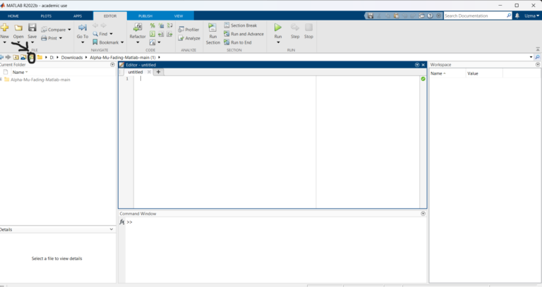
Open Matlab and click on the ‘browse for folder’ icon as shown below.
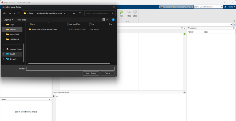
3.A pop-up window appears from which we can select the folder.
4. Run the main “.m” file.
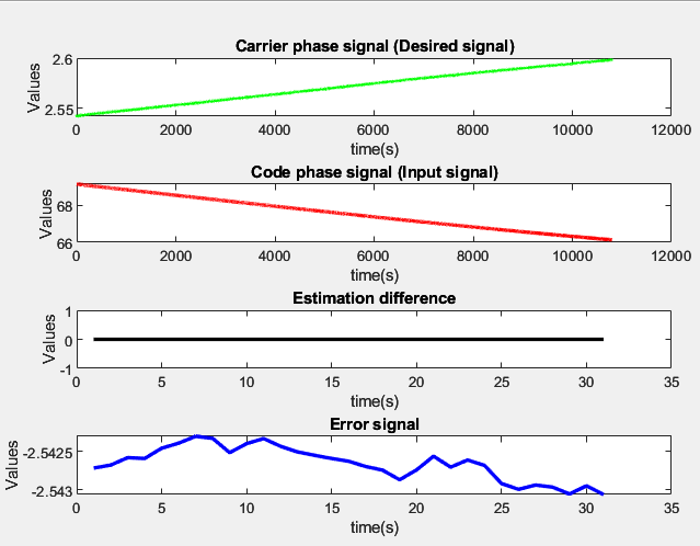
Results of Analyzing and Mitigating Multipath Error in the Indian Regional Navigation Satellite System for Improved Performance
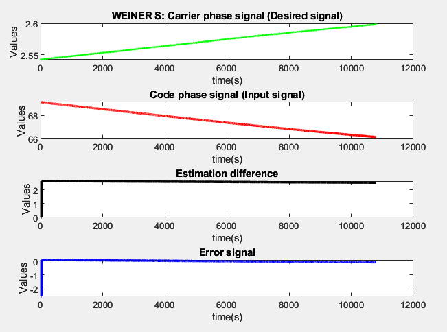
Fig 1: Weiner Filter
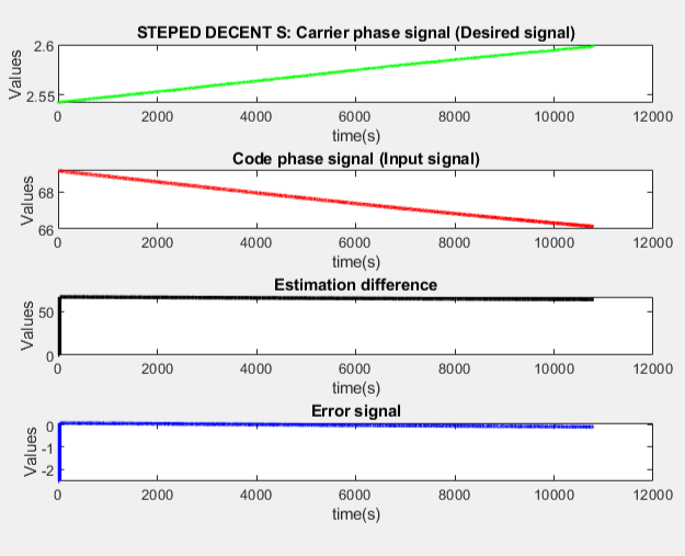
Fig 2: Steeped descent
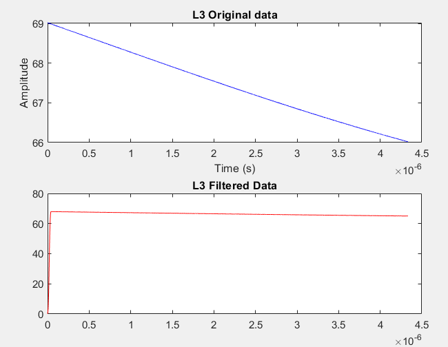
Fig 3: FIR S-band
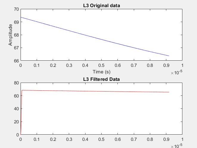
Fig 4: FIR L-band
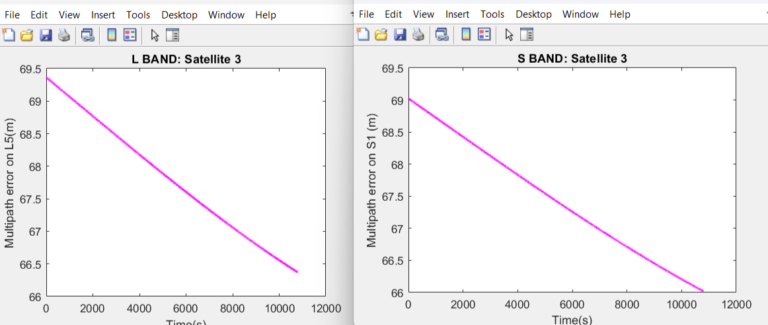
Fig 5: L-band and S-band of CMC technique
Issues Faced
- If we don’t give the proper full name of satellite data with the format, an error will occur.
- The folder path should be clearly mentioned in the MATLAB code for the extraction of satellite data.
Reference:
Contact details:
All the required data has been provided over here. Please feel free to contact me for model weights and if you face any issues.
